
FLIGHT PLANNING
The regulations put a pretty heavy burden on someone acting as pilot in command: The PIC most "become familiar with all available information concerning the flight". The "all available" is not very well defined... This is were flight planning comes into play.
Before any flight it is necessary to do some planning. The term 'flight planning' usually conjures a picture of pilots loaded with charts, calculators (E6B), track measuring devices, pens and markers, etc. While true, in a sense, flight planning is much more than just finding the route, calculating the distance, flight time and checking if your airplane can make the trip without stopping for fuel, if it can maintain the necessary altitude etc. It is also to check the weather, the NOTAMs, obtain information about the departure and arrival airports (and alternates). Even for a short local flight the prudent pilot will check things like weather and NOTAMs. I personally find flight planning enjoyable. Something I will do just for the fun of it; for trips I'd like to make, plan to make or just, well, for the fun of it.
Route planning
The first thing to do is to decide where to go and how to go there. In short, come up with a route. This is where aeronautical charts and route planning comes into play. Software based flight planners can be of great help, especially for longer trips. I use the Jeppesen FliteStar package. It 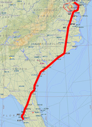 is a bit pricey but has lots of nice features – and it allows me to down load the route to my handheld Garmin 496 GPS. You can read more about the Jeppesen FliteStar in the link below. AOPA has a free online route planner available to anyone who is an AOPA member. ForeFlight is a new flight planner aimed at iPhone and iPad users. DUATS is the traditional alternative to flight briefers but also has a nice route planning capability.
It is also necessary to find information about the destination airport(s), as well as information about the departure and any potential alternate airports. While most of the route planners (DUATS excluded) contain airport information, there are resources on the web that are aimed at airport information only. Here are a few links to resources one can find on the web.
NOTAMs and TFRs
The next thing to do check is if there are any Notices to Airmen or Temporary Flight Restricitions that will affect your route and/or airports. This can be an ardeous task even for a simple short VFR flight and it gets even more so for an IFR flight. Most of the time I will use the DUATS to check for NOTAMs for an IFR flight. A call to Flightbriefing and requesting a Standard Brief will also give you the pertinent NOTAMs plus TFRs. Here are some resources available
- FAA NOTAMs including GPS and CARF (see below)
- AOPA's NOTAM and TFR Locator
- FAA Temporary Flight Restrictions (TFRs)
- Special Use Airspace (SUAs)
- DUATS
FAA NOTAMs are retrieved by airport identifier (or NOTAM number). This site also contains GPS NOTAMs as well as ARTCC TFR NOTAMs and CARF NOTAMs. CARF stands for Central Altitude  Reservation Function and is the organization responsible for processing altitude reservations (ALTRVs) for military operations. These types of NOTAMs are designed to keep non-military airplanes clear of military operations. They also give authorization for military aircraft to conduct operations not normally allowed under standard ATC rules. The CARF type of NOTAMs was not covered in my private, IFR or commercial syllabus but is worth knowing about. These types of NOTAMs should be treated like Special Use Airspaces (SUA), you should avoid flying in the area described in the NOTAM while the area is active.
Weather
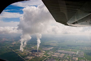
Weather information is a very important part of flight planning. Regardless of whether one is flying VFR or IFR knowledge about the weather may define all the other aspects of the plan, the route, airports to use, etc. It is also one of the more finnicky aspects of planning as the weather is very dynamic and our forecasting capabilities are far from perfect. I have a web page with several good-to-have links. Here are few of the most pertinent ones
Knowledge about weather, the weather products available and how to use them is of outmost importance for pilots. A very useful and good resource is Scott Dennstaedt's weather site: AvWxworkshops. Scott has a large number of workshops explaining how to interpret weather, use weather products. In addition there are many useful links and tips. Highly recommended to anyone who wants to go beyond reading TAFs and METARs.
Weight and Balance
An aircraft needs to be within the weight limit as defined in the Pilot Operating Handbook for a particular airplane. Furthermore, the center of gravity needs to be within the bounds as given in the Pilot's Operating Handbook. The latter is usually only a few inches long. The penalty for beign out of balance are severe as can be the case for exceeding the weight limit. These calculations are bone simple but the Pilot's Operating Handbook often tries to make it more complicated than it is. To get to total weight, sum all the weights (pilot, passengers, luggage, fuel). To calculate the center of gravity, take the sum of all weights at a given station (that is, front seat, back seat, 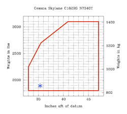 luggage compartment) multiply it with the "arm" (given in the POH). This gives the moment. Sum all the moments and divide by the total weight. This gives you the location of the center of gravity. Voila! Don't forget to check that it really is within the bounds given in the POH.
Most airplanes will change their center of gravity slightly as the fuel is burned off. For most, however, this is a small change and the CG is still well within the limits if you started out within the limits. There are, however, a few airplane types where the change of CG is large enought that you may end up outside the CG limits. Better check your POH.
If you want to learn more about weight & balance calculations I can strongly recommend the FAA Pilot's Handbook of Aeronautical Knowledge. Chapter 9 is solely devoted to weight and balance. Btw, this is the cheapest (it's free) source of aeronautical knowledge you can find, and among the best.
Aircraft Performance
The aircraft performance is of course part of the flight planning; can my airplane take off with the current load, the runway length, etc.; will my fuel take me all the way to the destination given the route, weather, etc? Can I climb high enough to avoid terrain? There are many factors and they depend on all the other parts of the flight planning. Quite often flight planning is a repetitive process. After finding out the performance it might be necessary to re-think the route because of fuel concerns or weather concerns. The aircraft performance is one thing that is (usually) not found on the web. It is unique for each aircraft and the pilot needs consult the Pilot's Operating Handbook or similar document.